
Interviewer: Good afternoon, Mr. Mohapatra. Thank you for joining us today. To start, let’s delve into the recent advancements at the India Meteorological Department (IMD). It’s the first time in a decade the IMD has forecasted ‘above normal’ rainfall. Usually, IMD tends to be more conservative in the first long-range forecast. Does the IMD now have better tools?
Mrutyunjay Mohapatra (IMD Director General): Absolutely. Over the years, we have significantly improved our forecasting capabilities. We’ve transitioned from relying solely on statistical models based on historical data to utilizing dynamical models. In 2021, we introduced multi-model ensemble forecasts, which provide not only forecasts on spatial distribution but also monthly forecasts during the monsoon season. This has been a major breakthrough in our forecasting methods. We now offer forecasts for the entire monsoon season, enabling better planning and preparedness. Our accuracy has notably improved, with approximately 80% of our monsoon predictions since 2021 proving to be correct. However, there’s still room for improvement, especially considering variations from month to month and region to region.
Interviewer: That’s impressive progress. With such advancements, do you think long-range monsoon forecasts are still relevant, given the improved accuracy in shorter turnaround times?
Mrutyunjay Mohapatra: Absolutely. India’s diverse agricultural landscape heavily relies on rainfall, especially for rain-fed farming. Early-stage forecasts play a crucial role in planning water usage for irrigation, power, and industry. These forecasts facilitate adequate planning across various sectors, ensuring preparedness for different scenarios. Additionally, long-range forecasts provide policymakers and stakeholders with valuable insights into potential climate trends, enabling them to make informed decisions regarding resource allocation and risk management.
Interviewer: That makes sense. Shifting focus slightly, recent studies highlight the risks posed by dry and moist heat stress. Does the IMD plan to issue more public-friendly alerts on heat exposure?
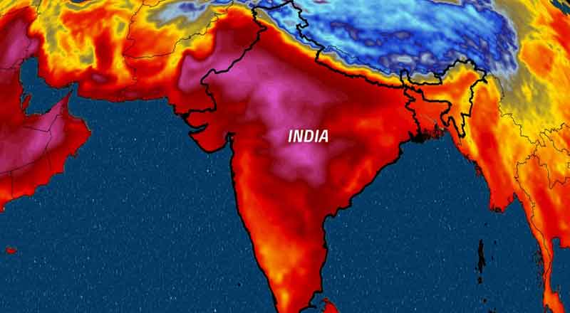
Mrutyunjay Mohapatra: Indeed, there has been a significant shift in our approach to heat waves. We’re now actively collaborating with state and central agencies to prepare heat action plans and disseminate alerts effectively. While we previously relied on broad norms to declare heat waves, we’re now considering additional criteria such as warm nights, humidity, and historical weather data. For instance, we issue alerts when both day and night temperatures exceed certain thresholds, taking into account humidity levels. These efforts aim to provide more accurate and relevant information to the public, enhancing their preparedness for extreme heat events. Moreover, we’re exploring innovative ways to deliver these alerts, leveraging digital platforms and community outreach programs to reach a wider audience.
Interviewer: It’s crucial to adapt to evolving weather patterns. Speaking of which, can you provide an assessment of the recent extreme rainfall event in Dubai?
Mrutyunjay Mohapatra: Certainly. The recent extreme rainfall event in Dubai was a result of several factors, including an active western disturbance and moisture incursion over the Arabian Sea. This convergence of weather systems led to rainfall exceeding 20 cm in a single day, which is unusual for the arid region. Such events occur when weather systems interact in unique ways, highlighting the complex nature of meteorological phenomena. Moreover, this same western disturbance is expected to cause rainfall in other regions like J&K, Himachal Pradesh, and the Indo-Gangetic plains, underscoring the interconnectedness of weather patterns across different geographical regions.
Interviewer: Thank you for that insight. Lastly, could you provide an update on the status of urban flooding mapping efforts?
Mrutyunjay Mohapatra: Certainly. Urban flooding mapping is an ongoing initiative aimed at addressing the flooding challenges faced by coastal cities like Chennai, Mumbai, and Kolkata. We’re currently expanding this effort to encompass additional cities, including Varanasi, Pune, Ahmedabad, Bengaluru, and Bhubaneswar. This project, executed in collaboration with the Centre for Development of Advanced Computing and the Ministry of Earth Sciences, focuses on enhancing urban meteorological services to provide focused forecasts within these cities. By leveraging advanced modeling techniques and real-time data, we aim to develop comprehensive flood risk maps that can assist urban planners and policymakers in implementing effective mitigation measures. Additionally, we’re working closely with local authorities and communities to raise awareness about flood risks and promote community resilience initiatives.
Interviewer: That’s a commendable initiative to mitigate urban flooding risks. Thank you, Mr. Mohapatra, for sharing your insights on these important developments at the IMD.
(With inputs from agencies)