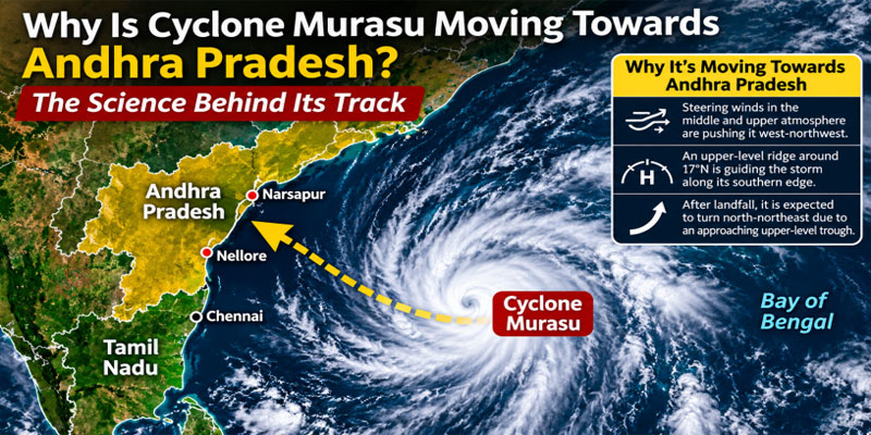
Cyclone Murasu made landfall on Andhra Pradesh’s south coast near Ongole in the early hours of November 3, 2026, bringing powerful winds, torrential rainfall and the threat of coastal flooding. The severe cyclonic storm crossed the coastline with sustained wind speeds of 100–110 kmph and gusts reaching 120 kmph. The India Meteorological Department (IMD) has confirmed that the landfall process is complete, with the system expected to gradually weaken as it moves inland. However, the immediate danger may give way to prolonged rainfall, waterlogging and infrastructure disruption across affected districts.
Landfall Confirmed Near Ongole
According to the IMD, Murasu’s landfall process began around 1 am on November 3, when the forward sector of its eye-wall cloud entered the Andhra Pradesh coastline. The anticipated landfall zone extended between Nellore and Narsapur, with Ongole emerging as the closest major reference point. In its 5:30 am bulletin, the IMD confirmed that the severe cyclonic storm crossed the coast between 3:30 am and 5:30 am near latitude 15.53°N and longitude 80.22°E.
At the time of confirmation, the cyclone's centre was located close to Ongole, approximately:
· 40 km southwest of Bapatla.
· 80 km north-northeast of Kavali.
· 130 km north of Nellore.
The landfall occurred broadly within the forecast zone, although the storm brought winds towards the upper end of the anticipated severe-cyclone range.
Powerful Winds and Heavy Rainfall Threat
Murasu struck as a severe cyclonic storm, generating sustained winds of 100–110 kmph and gusts of up to 120 kmph. These conditions posed significant risks to coastal settlements, electricity infrastructure, trees, communication networks and road connectivity.
Heavy to very heavy rainfall affected coastal Andhra Pradesh, particularly the Ongole–Nellore–Narsapur belt. Low-lying areas remained vulnerable to waterlogging, flooding and storm-surge-related inundation.
The combination of strong winds, intense precipitation and rough seas increased the possibility of damage to fishing settlements, agricultural land and essential services.
What Happens Next? IMD's Weakening Forecast
The IMD expects Murasu to move north-northwestwards after landfall, gradually losing intensity over land.
Its projected weakening trajectory is:
· By noon, November 3: The system is expected to weaken into a cyclonic storm, with winds of 80–90 kmph and gusts up to 100 kmph.
· By midnight: It is forecast to weaken further into a deep depression, with wind speeds of 55–65 kmph and gusts reaching 75 kmph.
Although the most dangerous coastal wind phase is expected to subside, rainfall-related hazards could continue inland.
Preparedness, Disruptions and Safety Concerns
Authorities had mobilised disaster-response teams ahead of landfall. Flight operations also faced disruptions, including cancellations, as coastal states prepared for the cyclone. Fishermen were advised to remain ashore amid warnings of very rough sea conditions.
The Real Challenge Begins After Landfall
Murasu's successful passage across the Andhra Pradesh coast does not mean the threat has disappeared. The priority now shifts towards preventing inland flooding, restoring electricity, clearing damaged roads and maintaining essential services. Timely evacuation, public cooperation and strict adherence to official advisories will remain critical. The effectiveness of post-cyclone relief and infrastructure restoration will ultimately determine how quickly affected communities recover.
(With agency inputs)